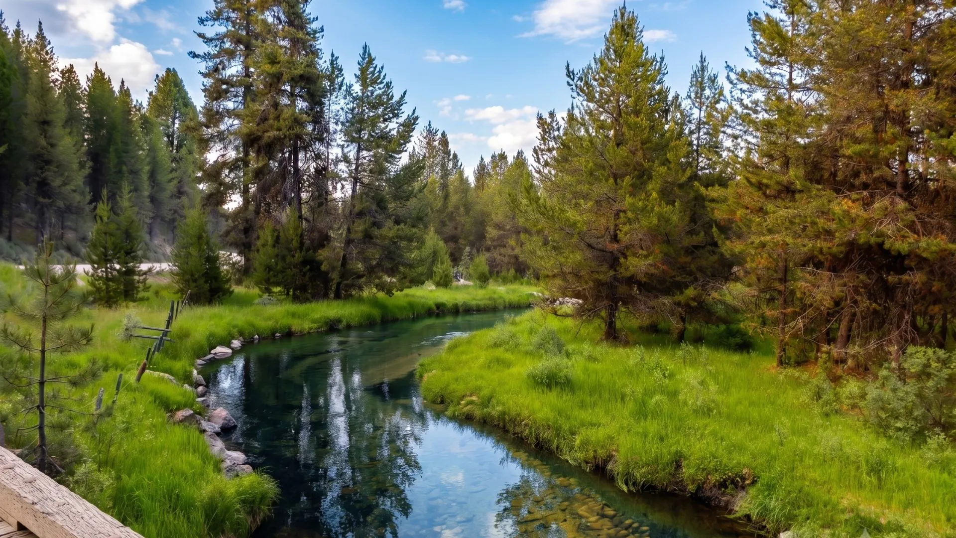
There is a moment every buyer describes the same way. They step out of the truck, look across the valley, and go quiet. The mountains are doing what they always do. The river is where it has always been. But something clicks. That land stops being a listing and becomes a life they can picture living.
Your job as a realtor is not to manufacture that moment. It is to engineer every condition that makes it possible and then give buyers the language, visuals, and data to justify the decision their gut has already made.
Idaho’s natural assets are a competitive advantage unlike anything a subdivision can offer. But raw beauty is not a marketing strategy. Here is how to turn what you see from the road into a compelling, defensible, high-converting case for acreage in Idaho.
Table of Contents
Why "Great Views" Is Not Enough Anymore
Buyers of rural acreage in Idaho are more sophisticated than ever. They arrive with Zillow tabs open, elevation data pulled from Google Earth, and a general awareness that “scenic” is a word every listing uses. Vague language is not just unhelpful — it signals that you do not know the property well enough to sell it.
The realtors winning deals in 2026 are the ones who show up with specifics:
- Watershed proximity
- Wildlife corridor designations
- Recreational access points
- Conservation easement history
- Fire risk scores
They combine that data with visuals that make the land feel real before boots ever touch the ground.
The goal is a listing that answers the buyer’s spoken question, “What am I getting?” and their unspoken one, “Can I trust this person?”
The Three Layers of Natural Asset Value
When you are marketing acreage in Idaho, natural assets fall into three distinct categories of value. Each requires a different communication strategy.
1. Visual Value
This is what stops the scroll. Ridgeline profiles, river bends, aspen groves, volcanic rock formations…these are the emotional entry points that turn a casual browser into a motivated buyer.
What to do:
- Invest in drone footage, not just drone photos. A slow orbit of a property at golden hour, descending into a meadow or tracking a creek line, communicates scale and beauty in a way no still image can. Post the raw flight as a dedicated listing video, not buried inside a slideshow.
- Add seasonal photography when possible. A property that looks one way in July and another in October has twice the story to tell. Buyers purchasing land for long-term use want to know what they are getting year-round.
- Use GIS overlays on aerial images to mark sight lines, elevation changes, and neighboring land uses. A labeled aerial that shows “unobstructed southern exposure to the Sawtooths” is more credible and more memorable than a caption that says the same thing.
2. Recreational Value
Idaho’s outdoor recreation economy is one of the strongest value drivers for rural Idaho land. Proximity to hunting units, fishable water, trail systems, ski areas, and BLM or Forest Service trailheads directly affects buyer pool size and price tolerance.
What to do:
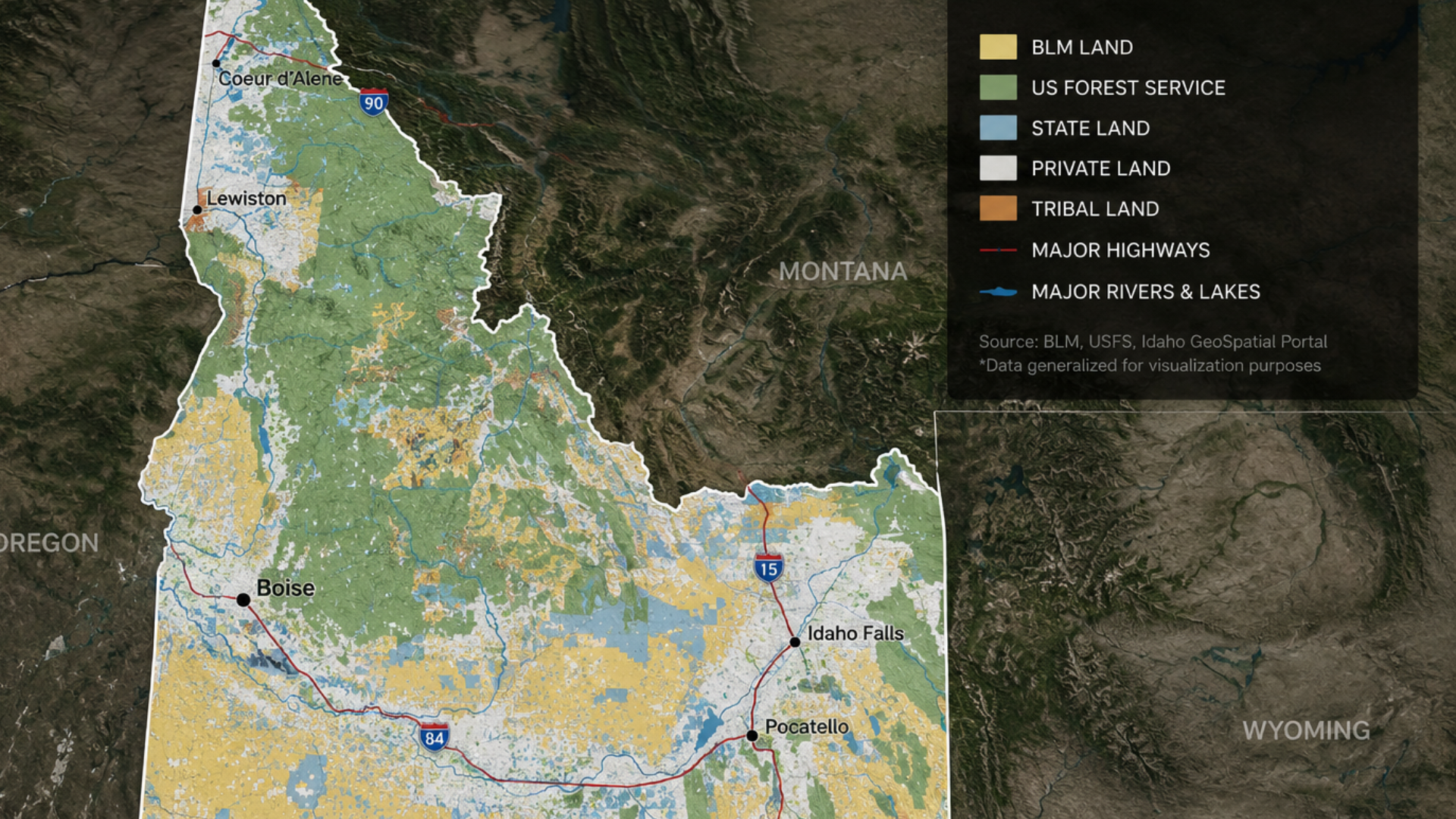
- Map it explicitly. Use a custom property map that shows the parcel boundary layered against Idaho Fish and Game hunting unit boundaries, USFS roads, and public land adjacency. Tools like onX Hunt, CalTopo, or ArcGIS Online let you build this without a GIS degree.
- Quantify access, not just proximity. “Borders public land” is good. “Shares a 1.2-mile fence line with Caribou-Targhee National Forest, providing direct access to Unit 65 elk hunting” is a listing that sells itself to the right buyer.
- List the fishing data. If a creek or river runs through or borders the property, pull IDFG stocking records or stream survey data. Mentioning that the reach holds wild Westslope cutthroat is not bragging — it is due diligence that separates you from every other agent who just says “great fishing.”
3. Conservation and Stewardship Value
This is the layer most realtors leave on the table. A growing segment of acreage in Idaho buyers, particularly those relocating from urban markets in California, Washington, and Colorado, place significant value on land that has been managed thoughtfully or carries conservation protections.
What to do:
- Research the land’s history before you list it. Has it been in a conservation easement? Does it border a wildlife corridor identified by the Idaho Department of Fish and Game or a land trust? Is it enrolled in a USDA conservation program? These facts add credibility and attract a buyer profile that is less price-sensitive.
- Know the difference between a conservation easement and a deed restriction, and be able to explain both clearly. Buyers who value conservation want to know what protections exist and what flexibility they retain. This knowledge positions you as an advisor, not just a transaction facilitator.
- If the land has no formal protections but has been managed responsibly by controlled burns, native grass restoration, and riparian buffers, document it with photos and tell that story. Land with a history of stewardship commands a premium with the right buyer.
Storytelling Techniques That Convert
Data builds trust. Story builds desire. You need both.
The most effective listings for acreage in Idaho do not read like spec sheets. They read like the opening chapter of a life someone wants. Here is the structure that works:
- Open with place, not features. Start the listing description with a scene, not a bullet point. “At 4,200 feet, mornings here arrive with mist off the river before the valley wakes up” tells a buyer more about a property than “4,200 sq ft custom home on 80 acres.”
- Anchor the story in a specific use. Who is this land for? The elk hunter who wants a private base camp. The family that wants horses and space. The couple relocating from Seattle who want silence they can count on. Buyers self-select when you are specific. The ones who do not see themselves in the story move on. The ones who do call immediately.
- End with scarcity that is true. Idaho has millions of acres, but the right combination of water rights, public land adjacency, views, and buildable terrain in a single parcel is genuinely rare. If that is true of the property you are selling, say so directly and explain why. “Properties with year-round creek access, southern exposure, and direct Forest Service border in this county turn over once every several years” is a close that respects the buyer’s intelligence.
Tools Worth Learning
You do not need to be a GIS analyst to use these effectively:
- onX Hunt / onX Land — property boundaries, public land adjacency, hunting unit overlays. The land version is built for exactly this use case.
- CalTopo — topographic mapping, slope analysis, watershed boundaries. Free tier is sufficient for most listing work.
- Nearmap or Google Earth Pro — historical aerial imagery to show how a property has changed or stayed the same over time.
- Idaho DEQ and IDWR databases — water rights lookup, stream adjudication records, water quality data.
- USDA Web Soil Survey — soil classifications, farmland designations, pasture productivity ratings.
- Idaho Fish and Game OnMaps — hunting unit boundaries, stream survey data, wildlife management areas.
The realtors who learn even two or three of these tools well are operating in a different league than those who rely on MLS photos and a lockbox.
The Listing Package Buyers Are Waiting For
Pull it together into a single, well-designed property package that goes beyond the MLS:
- A professional drone video (60 to 90 seconds minimum, unlisted on YouTube and linked in the listing)
- A custom property map with labeled natural features, public land adjacency, and recreational assets
- A one-page natural assets summary covering water rights, hunting unit access, conservation status, and any notable ecological features
- Seasonal photography (even two seasons is better than one)
- A narrative listing description written for a person, not an algorithm
This package does not cost a fortune to produce. It costs time and intentionality. But it changes the conversation from “what is the price per acre?” to “how do I make this work?”
The Opportunity in Front of You
Idaho’s landscape is not a backdrop. It’s a product. And like any product, it can be marketed poorly or brilliantly. The realtors who treat natural assets as quantifiable, communicable, and story-worthy are the ones closing deals on acreage in Idaho that others cannot move.
The land speaks for itself on a clear day in the field. Your job is to make it speak just as clearly in a browser tab at 11 pm when a buyer in Boise or Bend is deciding whether to make the drive.
Give them something worth driving for.
Realtors: Let's Bring More to the Table Together
Are you a realtor working with buyers on acreage in Idaho? DF Development partners with agents to bring land analysis, development vision, and local expertise to the table — helping your clients see the full potential of every parcel. Let’s talk about what we can build together.
Frequently Asked Questions About Marketing Acreage in Idaho
What makes acreage in Idaho attractive to buyers compared to other states?
Idaho offers a rare combination of affordable land prices relative to neighboring western states, direct access to public lands managed by the USFS and BLM, strong hunting and fishing resources, and relatively low property taxes on rural parcels. Buyers from California, Washington, and Colorado consistently cite Idaho’s acreage value and recreational access as the primary draw.
How do I determine the recreational value of a rural Idaho property?
Start by overlaying the parcel on Idaho Fish and Game hunting unit maps and identifying any streams or rivers with IDFG survey data. Note adjacency to National Forest, BLM, or state endowment lands, and calculate the linear feet of shared boundary. Check USFS road access for motorized recreation. Each of these factors can be quantified and included in your listing materials.
What is a conservation easement, and how does it affect acreage value in Idaho?
A conservation easement is a voluntary legal agreement between a landowner and a land trust or government agency that permanently limits certain uses of the land to protect its conservation values. Easements can increase buyer appeal among conservation-minded purchasers and may offer tax benefits to sellers, but they restrict future development rights. Buyers should review easement terms carefully before purchase.
What drone footage should I capture for an Idaho land listing?
At minimum, capture a wide establishing orbit of the full parcel, a low-altitude tracking shot along any water features, and a landing or reveal shot from the primary build site or viewshed. Golden hour footage performs significantly better than midday shots. A 60- to 90-second edited cut is the target length for listing use.
How do GIS overlays improve marketing for Idaho acreage listings?
GIS overlays add credibility and specificity to aerial images by labeling features buyers care about: parcel boundaries, elevation contours, public land adjacency, water rights, soil classifications, and hunting unit boundaries. A labeled aerial communicates more useful information in one image than multiple paragraphs in a listing.